A Geographical Lottery Game

No instruction manual survives for this globe, but the markings on the sphere and the accompanying cards suggest that the set was used for a kind of geographical lottery game.
A luxury toy
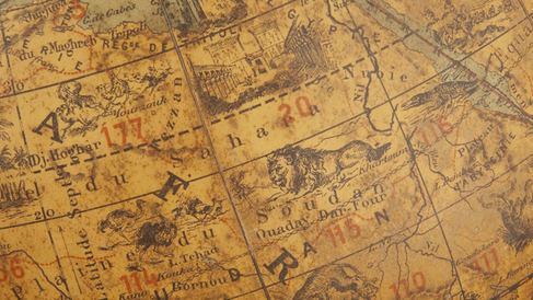
Unlike many of the geographical toys made for children, such as dissected spheres and pocket globes, this French set features a full-size table globe (Image 1), as well as 12 game cards. Each card shows part of a continent including not only its basic outline, but also local people, agricultural practices and native flora and fauna.
Stars have been drawn onto the surface of this Japanese astronomical globe using different coloured inks. These colours represent the jia (houses) of traditional Chinese astronomy and indicate the maker's interest in historical aspects of the subject.
Pocket-sized globes, measuring around 3 inches in diameter, had several functions including acting as status symbols for gentlemen and educational tools for children. Although the popularity of pocket globes peaked in the first half of the 18th century, makers continued to produce the items into the 19th century.
Three prominent instrument makers - Robert Morden, William Berry, and Philip Lea - collaborated to make this terrestrial globe at the end of the 17th century, which they sold, paired with a celestial globe, from their shops in the City of London.
A celebration of navigation
Although globes were of little practical use on board ships by the 17th century, they were nonetheless symbols of navigation, representing the world that sailors were attempting to explore. Reflecting this nautical theme, Morden, Berry and Lea have included navigational illustrations on their globe, such as ships, compass points and rhumb lines. More unusually, the globe also features the routes taken by two famous English explorers, Sir Francis Drake and Thomas Cavendish, during their voyages around the world. Successful explorers such as these were often celebrated as national heroes because the income of many European countries at this time was dependent on overseas trade, which necessarily required navigational skill. By including the tracks of Drake and Cavendish, this globe would have been part of the celebration of great English navigators, both recognising their achievements and encouraging other citizens to follow in their footsteps for the glory of the country.
The cards are hand-coloured and each has 8 numbered tiles that can be lifted out to reveal a black and white image of a significant feature of the region, often an animal or plant (Image 2). Where the same animal is shown on different cards the creature is generally depicted in a different pose, suggesting that the manufacturer was happy to spend money on producing a new image. Detail is also impressive on the globe itself - many of the squares are numbered, some of which correspond to those on the game cards. Geographical features including Tropics, isotherms and regional seasonal winds are shown, as are man-made features such as prominent buildings.
The level of detail and the hand colouring suggest that this was an expensive toy, either for the child of a wealthy family or perhaps for a schoolroom, where a larger group could have made full use of the 12 cards.
Games to play
The ring encircling the sphere is not graduated, so it would not have been possible to use the globe in calculations. It is far more likely that the globe was used with the cards to play a lotto-style game. The game leader could have spun the globe and stopped it with his or her finger, calling out the appropriate number from the square on the globe. Players could then remove the corresponding tile if they had it on their game card. The first player to have removed all their tiles would be the winner.
Using the globe alone could also have been enjoyable. Some numbers appear on more than one square, and some of the squares with the same number depict developing storylines, so children could use the images on the globe to guide their imagination through a story. In any case, in playing with the set children were exposed to the maps and images on the globe and game cards, and absorbed knowledge about matters such as geographical outlines, the operation of the winds and natural history.
Dating the globe
This set has no maker's inscription, but we can use features of the globe and game cards to tell us approximately when it was made. The fact that the globe was designed to teach children about diverse aspects of foreign lands means that we have clues from cultural, as well as cartographic, details. For example, the globe shows the English and French transatlantic telegraph cables reaching across to Cape Cod in America via the island of St Pierre. The French cable was laid in 1879, so the globe must have been made after this date.
Looking at the game cards can help us to pin down the date more precisely. Included on the cards are the Australian flag and the Flatiron building in New York (Image 3). The Australian flag was chosen in 1901, and the distinctively shaped Flatiron building was completed in 1902, so we can assume that the set was made soon after this. However, neither the globe nor the cards show the Vietnam Canal, built in 1914, so the set is likely to date from before this time. Additionally, the meridian of zero longitude on the globe passes through Paris, rather than Greenwich. While French delegates attended the International Meridian Conference of 1884, at which Greenwich was settled upon as the site of the Prime Meridian, France declined to take up the convention until 1911. From this evidence we can get a fairly narrow estimate for the date of production of between 1902 and 1911.
Katie Taylor
Katie Taylor, 'A geographical lottery game', Explore Whipple Collections, Whipple Museum of the History of Science, University of Cambridge, 2009.
