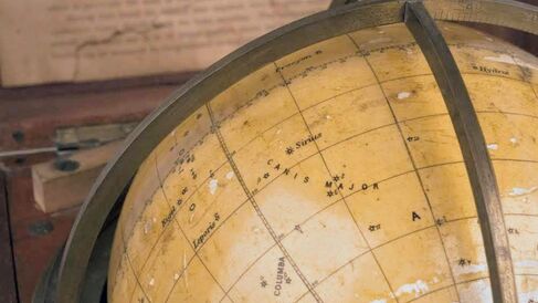
Identifying Stars at Sea

Many historians claim that terrestrial globes were of little practical use in navigation due to their lack of detail. This 20th-century celestial globe, however, was designed to be practically useful. It was intended to aid with the identification of stars at sea.
Several enterprising publishers issued globes that were readily portable. However, the resulting objects, such as dissected globes and pocket globes tended to be too small to include detail. John Betts (working from 1839, died c.1863) produced a globe that was both portable and large enough for the clear display of small features.
This combination globe-planetarium-encyclopaedia for children is just one of a handful made between 1899 and 1902 by Benjamín Tena, a landowner and amateur astronomer, in Villafranca del Cid, near Valencia.
A seafaring globe
Many historians claim that globes can have been of little practical use in navigation - it is difficult to make accurate measurements on a curved surface and the scale is too small to plot detail. However, these criticisms pertain to the terrestrial globe, where the surface of the sphere represents the surface on which the navigator wishes to travel, and which he must therefore know in detail. This 'Starfinder' globe (Image 1), designed by one Lieutenant English and made by Cary & Co. around 1925, provides a late example of a celestial globe intended to aid with the identification of stars for use in navigation. It is not known how widely the Starfinder was used, but it most likely became redundant in the mid 20th century with the development of new navigational technologies during the Second World War.
English's Starfinder globe is well adapted for navigational use at sea. Only the most important navigational stars are depicted on the sphere, and are shown as individual points as they are seen in the night sky, rather than as imaginative constellations. The box that holds the globe is about the same size as a marine chronometer (Image 2), so it would not have been too bulky for use onboard a ship. In addition, the mahogany box protected the delicate plaster sphere from damage in rough seas and provided safe storage space for the accompanying instruction booklet and the red and blue pencils used to make the markings required for certain calculations.
An independent instrument
Instructions for the globe suggest that it was designed to be used as a stand-alone instrument. If a navigator were using the Starfinder he would have no need for azimuth tables, which the author of the accompanying booklet considered to be "an immense advantage". Nor would a telescope be needed, since only those stars visible to the naked human eye were depicted on the globe.
Practice with the globe
All of the applications of the globe were practical, relating to observation rather than theoretical speculation on the positions of bodies that were invisible to the naked eye. If a ship's latitude were known, a navigator could find the approximate altitude and "true bearing" of any star, or conversely identify a star by its position even in cloudy weather when no other stars could be used as references. Discs were provided that could be attached to the globe to show the position of the Moon and planets on a particular day. However, discs were only provided for Venus, Mars, Jupiter and Saturn - those "of use to the ordinary observer".
The Whipple Museum's Starfinder
Most surviving examples of Starfinder globes have a brass meridian circle as well as a horizon ring that supports the globe in the box. The user would have rotated the meridian, which was set in a runner in the base of the box, in a groove in the horizon ring to set the globe for the appropriate latitude (see Image 1). However, the Starfinder held in the Whipple Museum's collection has just half a meridian circle, which sits below the horizon ring. The poles of the globe are mounted in the horizon and the sphere cannot be rotated along the meridian. It seems that someone unfamiliar with the operation of the globe might have remounted the sphere in its present meridian semicircle. The remounting, unfortunately, has made it impossible to adjust the globe for latitude and it is set constantly for use by an observer on the equator.
Katie Taylor
Katie Taylor, 'Identifying stars at sea', Explore Whipple Collections, Whipple Museum of the History of Science, University of Cambridge, 2009.
