Astronomy at Sea

Astronomy was crucial for British imperial power at sea.
British scientists working in the colonies encountered, employed, and collaborated with a wide range of local experts, informants, go-betweens, and assistants.
The uneven power dynamic typical to these collaborations—and the asymmetry of the historical record from which this Explore section draws—has tended to obscure the significance of indigenous labour and local knowledge traditions in imperial scientific pursuits.
Join us for the Cambridge Festival family weekend opening!
Free entry.
Join us for the Cambridge Festival Family Weekend and explore the history of science through our collection of microscopes, telescopes, and globes. Take part in family trails and visit our Learning Gallery, where you can engage with interactive handling boxes to discover topics such as Light & Sound, the Human Body, and Earth & Space.
Events on Saturday 29 March, 11:00am-4:30pm.
Happy to Co-Exist?: Lessons on Inclusivity in Science from Mauna Kea, Cambridge Festival Lecture.
1pm, booking not required. Aimed at an adult audience.
Scientific Women at the Whipple Museum.
3pm, booking not required. This talk is family friendly.
We are also open on Sunday 30 March, 11:00am-4:30pm.
When Britain sent a diplomatic embassy to China in 1793 to negotiate trade terms with the Qianlong Emperor, they were shocked when their scientific gifts were derided as unoriginal and childish.
Between 1830 and 1895, world powers competed in ‘The Great Game’, a shadowy struggle between British, Russian, and Chinese spies for political control of the Himalayan frontier at the far north of British India. Colonial forces sought to map and comprehend this vast wilderness, but found it too dangerous for British surveyors.
The solution was to send in ‘Pundits’, native agents of the British Survey disguised as lamas and Himalayan merchants.
The humanities and the sciences supposedly belong to separate cultures, but some of the world’s most celebrated images stem from scientific roots. Just as every picture tells a story, so too there are many different stories to tell about a picture. Who created it? And why? What places, objects and people does the picture show? Has its meaning changed over time?
In 1665, the diarist Samuel Pepys was so captivated by Micrographia that he stayed up all night admiring its detailed engravings. Robert Hooke’s powerful new microscope revealed a living world that had previously been invisible. A meticulous observer and talented draughtsman, Hooke laid bare the interiors of plants and minerals as well as displaying blown-up versions of the fleas, lice and other tiny creatures that tormented human beings. A delightfully eloquent writer, Hooke created an ostensibly scientific book that provided a strong religious injunction to contemplate the beautiful design of God’s creation.
Like novels or plays, pictures carry complex narratives that can be understood in different ways. Although there can never be a definitive interpretation, greater knowledge of the facts, context and possibilities illuminates even the most familiar of pictures and leads to greater appreciation.
Talk by Patricia Fara.
Booking is not required. Free - drop in.
Observatory data-gathering and the practical skill of observing sun and stars aboard ship both played a vital role in tackling the naval challenge of the age: finding location at sea accurately.
In Britain, improving the tools and techniques necessary for safe navigation became a major concern for political and scientific elites.
Latitude from the sun
Observing celestial objects was an essential skill for navigators in the age of imperial expansion.
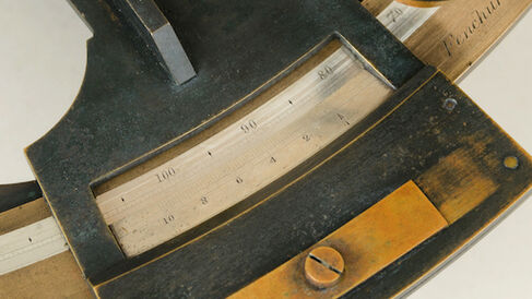
Instruments like the backstaff (Image 1, above) and octant (Image 2, right) were used to measure the altitude of the sun or pole star above the horizon, from which both local time and latitude (location north–south) could be found.
Longitude from the moon
Finding latitude at sea was relatively straightforward. Finding longitude (location east–west) was not. The instrument shown in Image 3, the sextant, would provide the most reliable and widespread solution.
The challenge for instrument-makers was dividing the sextant’s scale precisely enough that it could take measurements the backstaff and octant couldn’t: of the angle between the moon and certain prominent stars, down to a fraction of a degree.
These measurements provided a roundabout solution to a tantalisingly simple problem. To determine longitude, navigators needed both local time and time at a reference point (chosen to be Greenwich). Clocks proved inaccurate on rough seas, so astronomers offered a celestial solution—navigators could calculate Greenwich time by comparing measured ‘lunar distances’ with astronomical data tables.
The stakes were high: In 1714, following several losses to the British fleet, Parliament had offered a massive £20,000 prize for a solution to finding longitude at sea. For the ‘lunar distance’ method to prove practicable, it required affordable, accurate sextants, and lots of them.
The dividing engine
It was the famed London instrument-maker Jesse Ramsden who developed the first practical solution to making sextants quickly, accurately, and in large numbers. His answer was a machine: the dividing engine (Image 4).
To find longitude, a sextant’s divided scale needed to measure angles between moon and star accurate to better than one-sixtieth of one degree. Ramsden could divide the scale on his sextants by hand, but this was time-consuming work.
The mass-production of sextants required an industrial solution, so the Board of Longitude funded Ramsden to mechanise the process.
His first dividing engine, with 2160 teeth cut at precise regular intervals and driven by an endless screw, could do in minutes what it had taken weeks to do manually. Ramsden’s design was made public and rival makers soon built copies, including the Whipple’s example.
As a mass-produced commodity, sextants soon became an essential tool of open sea navigation. They were often used in conjunction with another famous technology developed with the support of the Board of Longitude: the marine chronometer.
Joshua Nall
Joshua Nall, ‘Astronomy at Sea’, Explore Whipple Collections, Whipple Museum of the History of Science, University of Cambridge, 2020.
